Übersreik is a free town of medium size, situated on the River Teufel a little downstream from the Grey Mountains. It is the seat of the von Jungfreud lands, with a ferry system connecting the town to other parts of the River Teufel.[1a]
The town sits astride an important bridge where the road from Bögenhafen to Dunkelburg crosses the river, and trade flows along the road as well as downriver to Auerwald, Grünburg, Kemperbad, and Altdorf. In the mountains to the south-west of the town sits the infamous Castle Drachenfels, and to the south-east is the small dwarf hold of Karak Azgaraz.[2a]
Because it is situated at the mouth of the Grey Lady Pass, Übersreik is perhaps the most important town in the foothills of the Grey Mountains. Its position on the Teufel river makes it the port of choice for people wishing to move their cargoes from the mountains by river. A recently made Free Town, it received its charter from Graf von Jungfreud just two years ago. Unique in the Reikland, Übersreik’s Town Council includes representatives of the local Dwarf clans, as a way to ameliorate any disputes over mining rights.[1b]
Übersreik’s houses are mostly made of stone and timber, a sign of the strong Dwarf influence here. Its walls are stout, and connected to them is the great fortress of Black Rock, home of the von Jungfreud family and one of the Empire’s main defences against invasion from Bretonnia.[1b]
Over the centuries, Ubersreik has gone through many changes. Some minor, others more significant. New districts and businesses have grown and prospered, while just as many have failed. Assaults by Greenskin and Beastmen forces have taken its toll on the outer defences and outlying lands, though the guilds do what they can to ensure the town's defence – and thus their own profits and trade.[2a]
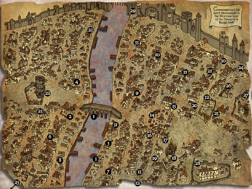
Map Legend
Maps for Ubersreik vary greatly, based on a combination of factors: the skill of the cartographer, his vantage, the period during which the map was commissioned, and of course who commissioned the map in the first place. The map here, while slightly dated, remains one of the more reliable and detailed maps for a large portion of Ubersreik.[2a]
- Bridge
- Customs House
- Red Moon Inn
- Rugger's Boarding House
- Boatmen's Guild
- The Docker's Arms
- Guild of Boatbuilders
- Temple of Ranald
- Butchers' Guild
- Metalworkers' Guild
- Carpenters' Guild
- Axe and Hammer Inn
- Borgun's Brewery
- Market Square
- Town Hall
- Temple of Sigmar
- Temple of Verena
- Temple of Shallya
- The Physicians' Guild
- Merchants' Guild
- The Waterfall
- Magnus' Tower (Ubersreik Garrison)
- Watch Barrack Stations (multiple locations)
- The Emperor's Rest Hostel
- Morr's Field
- Baron Manfred's Mansion
- Aschaffenberg Mansion
- Von Bruner Mansion
- The North River Tower
- Madame Beaumarteau's Costume Shoppe
- The Bridge House
- Fenstermarcher Manor
- Karstadt Townhouse